
Golly, I cain‘t never remember, is the Dome right kitty-corner to the Melrose? Weren‘t there the Richelieu ”˜tween ”˜um? I kin hardly recall. Reckon there ought to be a map.
Reader, we hear this sort of comment often, though we are yet to understand why it is forever posed à la Opie Taylor. That notwithstanding, it is a reasonable query, and rest assured we are working on a map of Bunker Hill, replete with requisite names and addresses and footprints, and in a perfect world, will also include neat stuff like topographies, chronologically morphing blocks, and rollover, uh, hyperlinks. While I cannot promise all or any of the futuristic ideas I believe I‘ve heard bandied about, it should definitely have pretty colors, and by the next time you go to MOCA, you‘ll be able to call up the map on your PocketEniac™ and say “ah yes, we‘re just now on the site of the (tap tap tap) Lovejoy Apartments.”
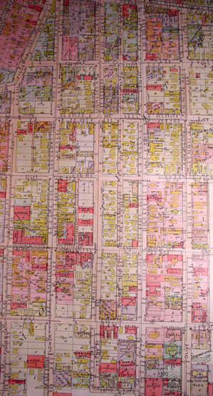
Until such time, let me offer you this map. It has none of the aforementioned geegaws, save for the pretty colors, and only comes in one year: 1921. Behold, Baist‘s Real Estate Atlas of Surveys of Los Angeles. You may have heard of the Baist‘s map; you can get a good look at it here (and their 1910 outing here). Plat Seven is the one to click for Bunker Hill. I suggest you head down to Central Library in a couple weeks and take a gander at an in-the-flesh Baist‘s. Please be advised that as regards pretty colors, red=brick, yellow=frame, beige=stone.
Soooo…here you go!
Bunker Hill!
Bordered by Temple, Hill, Figueroa and Fifth!
Ok, so this doesn‘t do you any good.
Let’s look at something up close. Something we can really sink our teeth into.
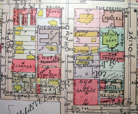
Now we’re cooking with gas. Above, Hope, Grand and Olive run north. There’s the Fremont and Zelda along Fourth. The Sherwood is yet to have the Edison as her neighbor. And T stands for Trenton. (Bottom right, note Neher & Skilling‘s 1910 Auditorium Hotel, which once existed in all its finial’d glory, before mid-30s streamliny reincarnation into the San Carlos hotel [dig the 1955 Armet & Davis Googies addition]…Neher had a hand in designing the hotel’s big brother, the Auditorium itself, which also underwent a cleanlining).
Alright, off somewhere else:
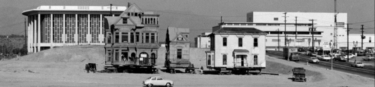
Between Second and Third; I’ve typed in street names up top to keep y’all oriented (that’s Bunker Hill Avenue between Hope and Grand). Familiar faces–façades? footprints?–abound: Marcella, The St. Regis, Van Fleet, The Elmar, the Brousseau Mansion, the Dome (still listed as the Minnewaska) and of course the Alta Vista, venerable home of John Fante, model for Arturo Bandini’s residences in Ask the Dust and Dreams from Bunker Hill. Many other tales on this blog occured in as-yet-unnamed locales; we now know from the particular slice of mappery above that this tale occured at The Raymond.
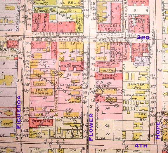
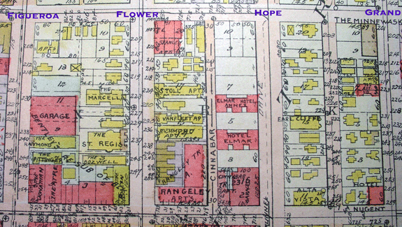
The Vanderbilt! The Imperial! Such regal names for two of my favorite places on the Hill. And the 300 block of South Flower is rich with goings-on, most notably at the Glenview. And yes, that’s the Hildreth down at the corner of 4th and Hope.
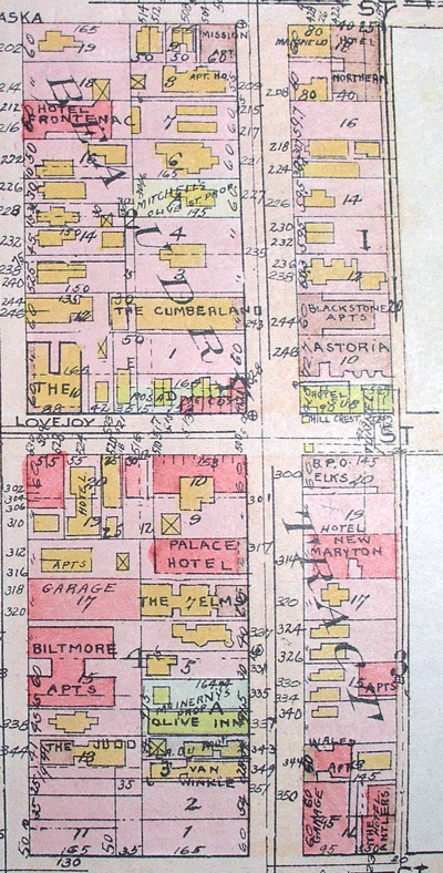
I want to add that the footprints of the buildings are not Sanborn-quality; do not take them as gospel. And at 321 S. Olive, that’s the Ems, not the Elms. So, ok, not everyone at Baist’s was as exacting as a Sanborner. Nevertheless, gaze here upon the glory of the Northern! Places of unusual unusualness! Herein lurks the future CRA offices themselves. And more of the usual suspects–the Astoria, the BPOE.
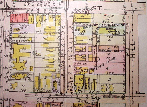
In 1921, we still had 411 and 409 standing on West First, though the Hotel Locke is gone…and if you’re wondering what it is I’m talking about, you can always consult the egregiously over-detalied mapping on the subject in this post, and this. And notice how 425 was called the Rio Grande. There’re our old pals the Richelieu, Melrose, Argyle and Moore Cliff.
Well, you get the idea. As we cast our light on bulldozed hills and fallen homes (and as you get to know the forgotten folk whose culture was so different, but whose attitudes were so similar to yours) perhaps when you dream of Bunker Hill, you’ll be able to traverse the grand avenues (and dart down the alleyways) with surety. Because as much as we’d like to rebuild Bunker Hill on some empty acreage, we had too much self-respect to get one of those "Everyone Deserves Everything" loans so popular until recently. We may have to content ourselves with designing a 3D tactical shooter, with HLSL and dynamic tonemapping. Again, until such time, we have this map.
Special thanks to Kim Cooper, who hipped me to the Baist beast’s whereabouts, and without whom I couldn’t have snatched it up.
I was at the Central Library yesterday and was able to view Baist’s Real Estate Survey of Los Angeles (1921) in person in the History Department on the lower level. It’s such a great experience to be able to hold history in your hands and imagine youself visiting any of the old places in downtown Los Angeles. I recommend not only going to view the new exhibit "LA Unfolded" on October 15th, but also viewing and touching one of the original map books.(The librarian was very courteous and let me take digital photos of any plates that I wanted).
Victorian Gentleman 1867
Los Angeles, CA